PHYSICAL distancing has been an important component of Australia’s coronavirus disease 2019 (COVID-19) response by reducing opportunities for transmission. Social media data allow us to measure the impact of physical distancing interventions on population mobility in near-real time (here and here).
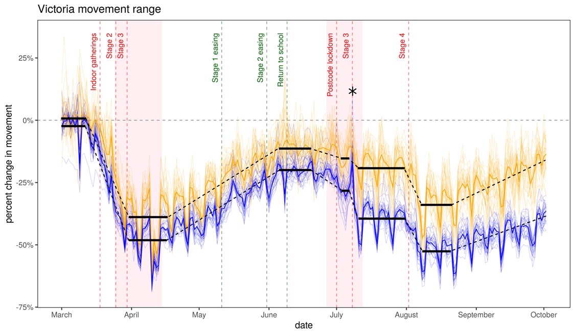
We used data provided by Facebook Data for Good to assess mobility trends in Victoria between March and September 2020. Facebook releases various mobility quantifiers derived from the GPS locations of users with location services enabled on mobile devices. The data are anonymised and aggregated to Local Government Areas (LGAs) subject to a minimum user threshold for privacy. We examined the derived quantity “movement range”, which measures the area travelled by users each day, relative to the same day of the week averaged over February 2020 (Figure 1).

Figure 1. Change in movement range relative to a February baseline as a function of time for each LGA in Victoria from 1 March to 2 October 2020. Traces corresponding to LGAs located in the Greater Melbourne region are colored blue, while those corresponding to LGAs in regional Victoria are colored yellow. Dark blue and yellow traces correspond to median values for Melbourne and regional Victoria respectively. Solid black bars show average values over selected intervals, which are discussed in the text (the dotted lines connecting them are guides to the eye). The asterisk illustrates the height of the mobility spike in Mornington Peninsula on 7 July just before Stage 3 second-wave lockdowns went into effect in Greater Melbourne. Dashed vertical lines correspond to significant events and policy announcements related to restriction levels increasing (red) or decreasing (green).
Following the introduction of lockdown restrictions in March 2020, movement range dropped to −48% of baseline in Melbourne and −40% in regional Victoria. Compliance with restrictions began to wane in mid-April, before restrictions formally eased, rising to −20% of baseline for Melbourne and −11% in regional Victoria.
In June, community transmission was detected in north and south-east Melbourne. On 1 July, lockdowns were announced for specific postcodes, decreasing mobility substantially in Melbourne (−29%) and more broadly across Victoria (−15%), indicating that many people changed their behaviour voluntarily. Restrictions were subsequently expanded to include Greater Melbourne and Mitchell Shire.
The day these restrictions came into effect there was a substantial “spike” in movement, with the Shire of Mornington Peninsula rising above baseline (+9%). Mobility in Melbourne decreased less under Stage 3 restrictions in July than in April (−40% and −48% respectively), potentially due to schools remaining open for some students. A divergence between Greater Melbourne and the rest of Victoria occurred at this stage, although mobility decreased slightly in non-Melbourne LGAs to −19%.
Stage 4 restrictions were introduced in Greater Melbourne on 1 August, accompanied by Stage 3 restrictions across the rest of Victoria. Mobility decreased substantially (to −52% and −34% in Melbourne and regional Victoria respectively), and has gradually increased since then to −37% in Melbourne and to −13% in regional Victoria on 2 October.
Mobility data provide a unique and timely insight into population behaviour. Our analyses quantify the impact of restrictions, the extent to which voluntary changes in behaviour precede formal restrictions, the duration over which populations comply with restrictions before adherence begins to wane, the potentially counterproductive movement trends that can precede formal restrictions, and the impact of targeted lockdowns both within and beyond targeted regions.
The outbreak in New Zealand in August 2020, following more than 100 days with zero cases, indicates that Australia will remain at risk of further outbreaks, even if suppression of community transmission is achieved. A real-time assessment of how populations respond to restrictions is essential to inform how they can be used to contain transmission while minimising disruption to social and economic life.
Dr Cameron Zachreson is a Research Fellow in the School of Computing and Information Systems, University of Melbourne. He studies the interplay between infectious disease, human behaviour, and public health policy.
Dr. Nicolas Rebuli is a Postdoctoral Fellow at the UNSW School of Public Health. His background is in stochastic modelling and he is interested in using data science to inform public health outcomes.
Lewis Mitchell is a Senior Lecturer in Applied Mathematics at the University of Adelaide. He studies how information moves over social networks using mathematical models, coupled with data science techniques. Lewis’s research interests are in computational social science, human dynamics, online social networks, as well as data assimilation and the mathematics of weather and climate.
Dr. Martin Tomko is a Senior Lecturer in Spatial Information at the Department of Infrastructure Engineering, University of Melbourne. His research is focussed on computational methods in spatial data science.
Dr. Nic Geard is a Senior Lecturer with the School of Computing and Information Systems at The University of Melbourne with expertise in simulation modelling and infectious disease dynamics.
The statements or opinions expressed in this article reflect the views of the authors and do not represent the official policy of the AMA, the MJA or InSight+ unless so stated.

 more_vert